I put Garmin’s Connect Plus Trails, breathing variations, and rucking sport to the test
Sunday Runday

In this weekly column, Android Central Wearables Editor Michael Hicks talks about the world of wearables, apps, and fitness tech related to running and health, in his quest to get faster and more fit.
The Garmin May 2025 feature update is relatively small, and two key features prop up Garmin’s paid subscriptions. I don’t need premium golf maps or a Stage Timer for marksmen, and I’ve had the Passcode on my Fenix 8 for a while. Instead, I set out to test the other new features: the rucking mode with pack weight, Pulse Ox breathing variations, and (most importantly) the Garmin Trails guide.
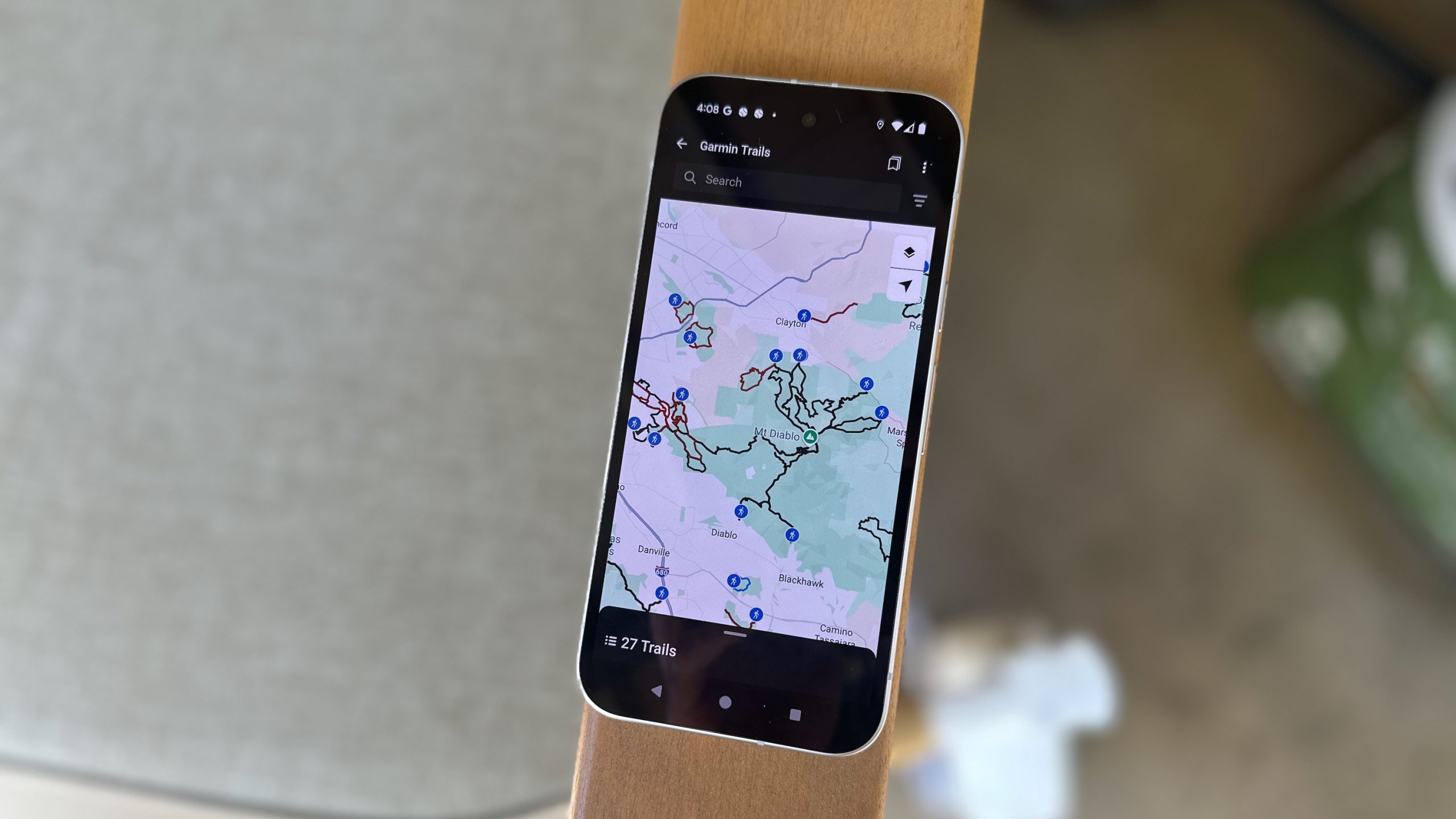
Garmin Trails is the company’s answer to AllTrails and Komoot. Any Connect user can search through local trails under More > Training & Planning > Garmin Trails, filtering routes by distance, total ascent, difficulty, popular months, and “features” like being dog-friendly.
You only need a Connect Plus subscription to save the trail to your courses or Garmin watch. Similar trails remain available in the Garmin Courses section, which requires no subscription to export them. Garmin had to balance not removing old features and incentivizing Connect Plus, so it made Trails instead of improving Courses.
Some early reactions to Garmin Trails have been negative, either because it’s currently limited to five countries or because it “shouldn’t” be paywalled as Garmin watches get more expensive. Judging Trails solely on its merits as a U.S.-based user, along with the new rucking tools, I’m generally positive on the feature, but have several reservations.
Garmin Trails needs your help to work

Most popular hiking apps require a subscription to sync community routes to your Garmin watch for offline navigation. No doubt Garmin hopes that offering a first-party alternative directly in Connect will make people cut out the middlemen (middleapps?) like Komoot and AllTrails.
First, the positives: Garmin Trails has robust filters. I can hover over the wider California Bay Area, say I want a hike with 2,000–4,000 feet of total ascent that’s no more than 15 miles, reaches any peak, and is dog friendly, and see all 49 hikes that fit that criteria within driving distance.
In my specific county, I can find 17 easy, 55 moderate, and 49 hard hikes within reasonable driving distance, then narrow down the list with either Loop, Out & Back, or Point to Point filters. It’s all useful context, and if you’re a casual hiker like me who might try one new route a month, that could last you for years.

However, most of the “Features” and ratings aren’t useful yet because they require user input. Garmin made sure to mark 250 dog-friendly Bay Area trails, but (hilariously) can’t find a single one that’s “Kid Friendly” or has “Forest” or “Flowers” to look at.
I spot-checked a dozen trails, and each had a one-paragraph summary that tended to be fairly generic, listing out the length, time to finish, what views you’ll see, and whether it’s dog friendly. Seriously, someone at Garmin loves dogs. You won’t get much other context.
This should improve with time as users fill in the blanks with reviews, and I like that hikers can tag specific Conditions like Temporary Closure, Trail Damage, Bugs, Crowded, and so on.
But Garmin has to play catch-up against AllTrails, Komoot, and other community-driven apps with years of context and photos, with an entire app dedicated to hiking rather than a single section of Connect. Garmin users will have to help prop Trails up as a service.

Garmin’s Trails list misses out on a huge number of trails found on other platforms. I checked around Mount Diablo, a local favorite, but saw no trails at the popular Artist’s Point parking lot where people typically start heading to the peak. All the hikes start along the park edge, meaning they’re intimidatingly difficult and almost twice as long.
More generally, Garmin Trails shows about 500 hikes in a huge portion of Northern California from Santa Rosa and Sacramento down past the Bay into Monterey; I can find over 500 trails in Contra Costa County alone on AllTrails.
Theoretically, Garmin’s selection is supposed to be curated, so casual hikers can skip to the best options. But I think it’s more accurate to say that Garmin finds most of the best starting points but defaults to one great hike option when AllTrails might show five or more variations from that same point.
You can “Customize Trail” to download it to Garmin Courses and try to shape it to your needs first, but I found it almost impossible to edit a course to be shorter, so at that point, you might as well make it from scratch and bypass Trails altogether.
Rucking and pack weight

I’ve been excited to test rucking on Garmin watches for months, ever since I jumped into the rucking fad last year. For those unaware, rucking takes the military training concept of carrying extra pack weight for training and applies it to everyday athletes, helping them build muscle and endurance on hikes that might normally be easy with a light pack.
With the update downloaded on my Fenix 8, I installed a 4-mile route from Garmin Trails, loaded up my pack with 25 pounds — tough for me, easy for most rucking enthusiasts — and drove to the trailhead.
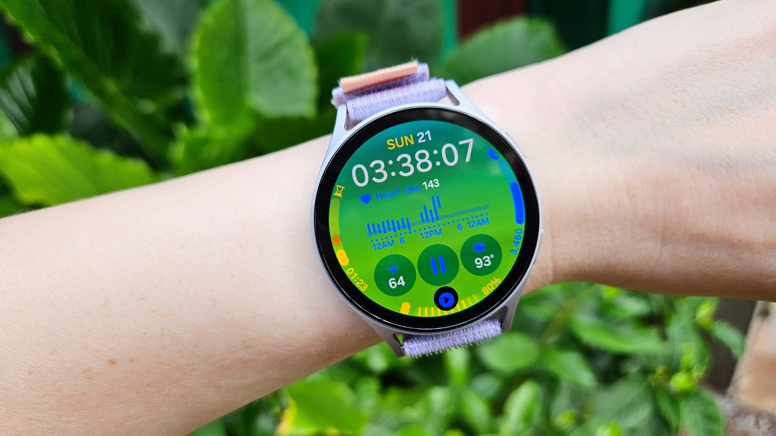
I had two choices: Either do an actual Rucking sport activity or choose Hiking and add my pack weight. In either case, carrying more than a few pounds prevents the activity from affecting your VO2 Max, and the Rucking profile seemed more likely to have specialized widgets, so I went with that option.

The default Rucking data screens show HR, distance, elevation, ascent and descent, hill grade, sunrise/ sunset times, a compass, and your map. And the post-workout screen shows the usual data like calorie burn and training load — only with your logged pack weight taken into account.
That’s all useful data, but it’s basically what you’d see on a Hike activity. Eventually, I’d want Garmin to display load-adjusted pace, stamina depletion, estimated muscle strain build-up, or other metrics specific to the amount of weight you’re carrying.
I’ve previously written about how cool it’d be to have some kind of Load Score, like Hill or Endurance Score, that takes your logged pack weight into account to judge how much weight you can safely carry and adjusts the score over time with new data.
Image 1 of 2


Returning to Garmin Trails, my on-watch route was quite useful in ensuring I stayed on trail, with occasional audio alerts before turns and a warning once I missed a turn and started to stray off course.
But I do have to roast Garmin’s recommended trail a bit. In the photo above, you can see how Garmin told me to climb over this immovable fence surrounded by barbed wire to stay on course. I had to go “off course” 0.2 miles to get to the actual turnaround point (which I knew from a previous hike).
Garmin does have a “Report an issue” field, so I told Garmin that it needed to update its map. I’ll be curious to see if Garmin changes its official Trail route, and how quickly.
Breathing variation

A lot of smartwatch brands are pushing towards sleep apnea detection, and Garmin’s new breathing variation tool steps in that direction.
Garmin watches have always been the best option for blood oxygen data because you can choose between spot checks, all-night data, or all-day data in the Settings, and they have the battery life to support it. Plus, you had in-depth HRV data to judge your physiological recovery and stress levels.
Now you get one more metric with breathing variations. Garmin attributes them to “lifestyle factors, your sleep environment, or other issues,” without specifically mentioning that sleep apnea might cause occasional or frequent issues.
I wore my Fenix 8 to bed and saw moments when I had a “Few” breathing variations, with the Sleep Score showing my SpO2 levels and breath rate per minute (brpm), both average and lowest.
As Garmin warns, it’s “not intended to diagnose, treat, cure, or prevent any disease,” but over time, you can see whether the signs suggest you should get sleep labs done for a potential issue. I’m glad that Garmin’s offering it and that it’s available on most recent Garmin watches.
Judging the May Garmin update
I didn’t need to retest the Passcode feature to say that it’s an important one for optional security that other brands already test. And I’m sure golfers with the Venu 3 will appreciate getting new tools like full-color CourseView maps, touch targeting, PlaysLike distance and Green Contours.
I’m generally a fan of this update! It’s a relief that my pack weight won’t skew my VO2 Max results anymore, and I’m happy to wait for the rucking profile to get more specialized tools in a future update, hopefully.
But for Garmin Trails, Garmin wearers need to start adding in the missing data to catch up with AllTrails and Komoot. The Connect+ hurdle may turn away some users who might otherwise have embraced it, which could slow this down.


Post Comment